Observers Ask, What’s That.....
odd yellow band that seemed to be a two piece band 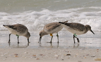
yellow plastic gizmo
strange silver and yellow squarish metal marker
had a yellow thick band on left leg. A tracker?
(comments reported via bandedbirds.org)
Good assumption on the tracker!
Photo Credit: John Young
In 2008, for the first time, dataloggers, also known as geolocators, made by the British Antarctic Survey (BAS) became available light enough to be carried by Red Knots. Scientists around the world were captivated by the possibility of gathering information that previously could only be obtained by costly expeditions to remote places on earth. The Delaware Bay Shorebird Working Group collaborated with researchers from Australia and Netherlands to design a leg mount able to carry the geolocator from the arctic breeding grounds to Tierra Del Fuego wintering areas, and back again.
During spring migration 2009, fifty dataloggers were deployed from New Jersey. The following May, three were recovered. In all, 250 dataloggers have been deployed from New Jersey, Florida, Massachusetts, Texas and Chile. Seventeen have been recovered. In the Pacific flyway, nineteen loggers have been deployed from Alaska on red knot.
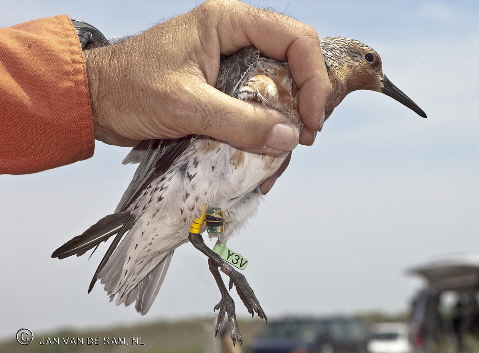
FL(Y3V) deployed on May 13, 2009 from Cooks Beach, NJ
Photo Credit: © JAN VAN DE KAM, NL
Recovery of a datalogger is tough business. 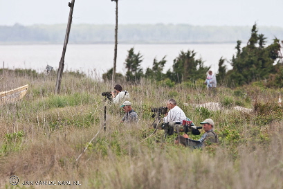
Tension mounts as scanners cull the flock for that one bright yellow flash
that indicates a datalogger bird is present.
Next is the stressful wait: Will the bird skitter its way into the catching area?
Can a safe catch for all the birds be called?
 Clive Minton's expression sums it up - relief for a successful recovery of Y0Y.
Photo Credit: © JAN VAN DE KAM, NL
The outcomes from the successful recoveries have been remarkable. Many surprising results have emerged, which could not be otherwise discovered. The knots flew amazing distances, flying for as much as 7 days without difficulty. The routes were quite direct, for example, crossing the Amazon basin rather than following the coast of Brazil. Weather occasionally pushed them far out over the ocean. Wintering areas have been found in Argentina, Brazil, the Caribbean islands, and US coasts. Unknown staging areas have been revealed. Breeding indications are recorded. All this, just from the recovery of a device the size of a little fingernail and lighter than a feather.
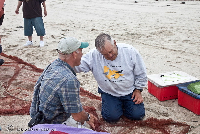
Looking for dataloggers May 23, 2010. FL(Y0Y) spotted!
Photo Credit: © JAN VAN DE KAM, NL
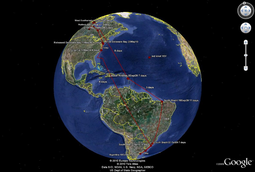
Journey for FL(Y0Y). Released May 10, 2009 at Cooks Beach, NJ and recovered May 23, 2010 at Reeds Beach, NJ.
The datalogger is as simple as a timer and a light sensor. It measures the time of sunrise and sunset. The sunrise time identifies the longitude, and the length of day the latitude. Take a look at this screenshot from the free website of Jurgen Giesen, www.jgiesen.de/SME/. It clearly shows the path of sunlight across our planet on 28nov2011 at 06:10am. The sun has passed over Southern Africa and is on its way toward South America.
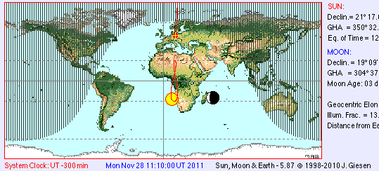
The sun is just rising on Newfoundland (latitude 48 x longitude -55), and, at that latitude, the sun is setting over Kazakhstan (latitude 48 x longitude 31). The length of day is the time interval between the two. Examine the map: on the whole planet, this length only happens here. Every spot on the planet has a different time of sunrise and day length.
The geolocator can record for 2 or more years, and retains the data indefinitely on a tiny microchip. It takes a reading every 10 minutes. Upon retrieval, the data is run through a program that processes the light signals. The program produces sunrise time and day length for each day. Using this information with a table of location versus sunrise/day length values, it is possible to determine the location of the bird each day. While the program does a great job for the initial filtering of data, it still takes meticulous analysis for the final interpretation of the data. Late sunrises or false night-falls can occur due to extraneous conditions. Cloudiness can affect the readings, so the data needs to be cross-referenced with weather conditions. Or just imagine roosting time in a dense flock with the “datalogger” leg tucked up. (case in point: check out the image associated with Honeymoon Island State Park resighting below)
How Your Resightings Help!
Part of the study is to monitor the health of the knots carrying a geolocator. Resightings in this database have been especially useful in that determination. If you spot a geolocator, it would be helpful if you take an extra minute to comment on the condition of the bird. Resightings also aid in tracking the geolocator birds that have eluded recapture. These observations let us know that the bird is well and fit!
Take a look at what we do know about our datalogger FL(1PM), thanks to reports to bandedbirds.org. Deployed on 3/9/2010, we know 1PM is alive and back in Florida as of the end of January 2014. Utterly tantalizing is where was 1PM between May and July each year? Did the bird make the journey to the Arctic from Florida? Let’s hope for a datalogger recovery to answer these questions.
Captures:
3/9/2010 - Longboat Key, Florida, United States
Resightings:
3/23/2010 - Longboat Key, Florida, United States
3/30/2010 - Longboat Key, Florida, United States
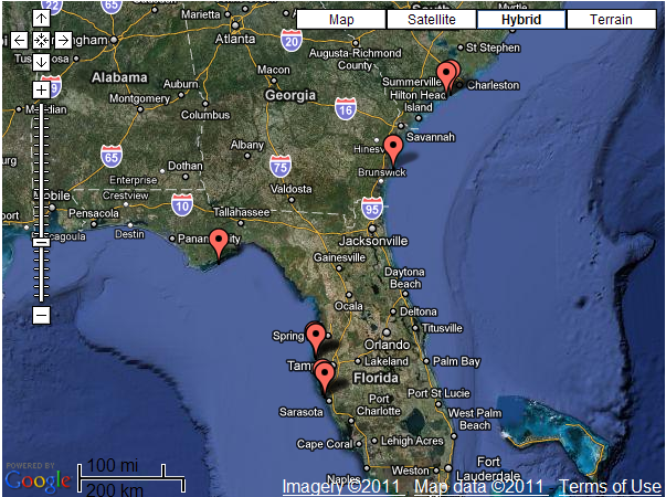
4/27/2010 - Honeymoon Island State Park, Florida, United States Click here to see a picture
5/18/2010 - St. George Island State Park, Florida, United States
7/4/2010 - Kiawah Island, South Carolina, United States Click here to see a picture
8/8/2010 - Botany Bay Island, South Carolina, United States
9/3/2010 - Wolf Island National Wildlife Refuge - Bar, Georgia, United States
11/18/2010 - Caladesi Island State Park - North, Florida, United States
11/30/2010 - Caladesi Island State Park - North, Florida, United States
1/11/2011 - Longboat Key - North, Florida, United States
8/8/2011 - Wolf Island National Wildlife Refuge - Bar, Georgia, United States
8/24/2011 - Wolf Island National Wildlife Refuge - Bar, Georgia, United States
9/8/2011 - Wolf Island National Wildlife Refuge, Georgia, United States
9/13/2011 - Egg Island and bars, Georgia, United States
9/21/2011 - Wolf Island National Wildlife Refuge - Bar, Georgia, United States
9/22/2011 - Wolf Island National Wildlife Refuge - Bar, Georgia, United States
9/23/2011 - Wolf Island National Wildlife Refuge - Bar, Georgia, United States
9/25/2011 - Wolf Island National Wildlife Refuge - Bar, Georgia, United States
7/31/2013 - Fort DeSoto - Mid Island, Florida, United States Click here to see a picture
12/31/2013 - North Lido Beach, Florida, United States
1/2/2014 - North Lido Beach, Florida, United States
Article Authors: Ron Porter and Jeannine Parvin
Additional Readings
Shorebird Researchers Document Red Knot's Record-breaking Flight
First results using light level geolocators to track Red Knots in the Western Hemisphere show rapid and long intercontinental flights and new details of migration pathways.
Look for a series of articles by Ron Porter about interpreting geolocator data starting April 2011 in the Wader Study Group Bulletin published by the International Wader Study Group.